

Apple Maps. Just typing the words can drive fear into the heart of any iOS lover.
OK, that might be a little extreme, but for the many users who were burned by Apple Maps with its introduction alongside iOS 6 back in 2012, the app doesn’t exactly bring up fond memories.
Apple Maps has improved a lot over the years. At WWDC in June, Apple made a point to note that its mapping app (which is installed by default) is used 3.5 times more than its closest competitor. That competitor, of course, would be Google Maps.
For a lot of users, Google Maps has become the preferred mapping app because it has features that Apple Maps just doesn’t. For instance, transit directions.
The original iOS Maps app (which was powered by Google Maps) had transit directions and this was a great way for users to get from place to place and plan routes, especially in cities like New York, where transit is incredibly important.
Although Apple allowed Apple Maps to link to third-party apps (including Google Maps) for transit directions, the lack of any native solution has held the app back.
In my personal life, I’ve switched from using Apple Maps to using Google Maps and CityMapper almost all the time.
But with iOS 9 coming soon, Apple is giving Maps new attention. Building off of some acquisitions (which include mapping services Embark and HopStop) and lots of additional TLC, it’s time to give Apple Maps another look.
Apple has added transit support to the last few public betas for iOS 9. Running the beta software on my iPhone, I decided to give the new transit-enabled Apple Maps a try in New York City to see if it could get me from place to place. More to the point, I want to know; Can it replace Google Maps?
Better place information and faster Handoff
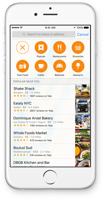
Aside from transit, one of the big areas Apple has focused on improving in Maps is its database of place information. Before, Yelp data and photos were pulled into a location’s card but now — depending on the location — information from Booking.com and Trip Advisor are available, too.
You can also see if a location accepts Apple Pay directly from the app.
Apple Maps is also designed to work faster with Handoff and Continuity, features between iOS and OS X devices. If you start looking at a route or a place on the iPad and switch to the iPhone, Handoff will now take you exactly where you were before in the map.
This will really come in handy when OS X El Capitan launches later this fall. Like iOS 9, Apple Maps in El Capitan will support better place data as well as transit information.
While Apple Maps now replicates more of the features of Google Maps and CityMapper, the experience is different.
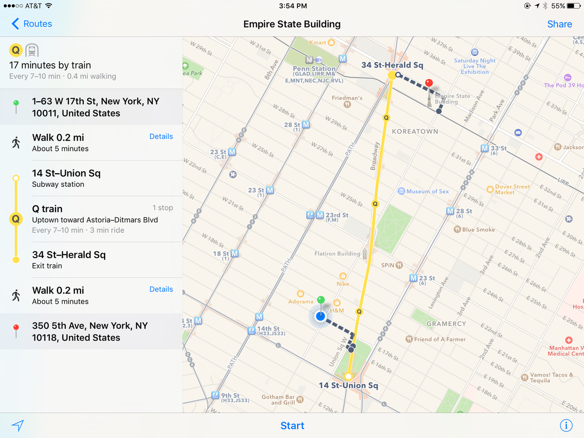
The subway routes are accurate and Apple Maps even has information to show the best subway entrance for your destination — as well as flyover information on the map itself that shows exactly where you are.
In New York City, Apple Maps uses the MTA’s API to provide real-time transit information for a number of lines. This can sometimes alter what route you need to take.
Delays and incidents are also fed in from the MTA and are viewable inside the app. This is great because it makes it easy to decide, say, whether you should take the Q or if the N/R is going to be better.
The experience is similar to Google Maps, where you can route to a destination with an “arrive by” time to let you know when you need to leave. In iOS 9, you’ll get reminders on your phone of when you need to leave if an appointment in you calendar has address location information. Apple Watch owners will also get notified on their wrist.
I was impressed with the transit access in iOS 9. It worked almost identically to Google Maps. One nice part of Google Maps is that I can also call an Uber from within the app. I’d like to see Apple Maps add support for car services, too.
Offline usage for transit directions and Apple Maps in general is still limited. To me, this feels like one of the biggest areas to improve. Living in a city where I’m often underground when I need information about my route, it’s great that I can see general directions and routes within Apple Maps — but I worry that if I load another app or go do something else, it’ll all disappear from the cache.
Google Maps is better about this — especially if you enable offline mode — and third-party transit apps are even more adept at getting stuff done.
Having better offline support would also be a win for using the iPad out and about because the iPad is truly great as a navigation tool. I have an LTE iPad, but lots of people don’t. Having the ability to load a map before I leave with some landmarks and a trip plan could be excellent for tourists.
Not a replacement for a solid transit app
Although the service worked well for me in New York City — I didn’t get on a wrong train or bad directions – Apple Maps still isn’t a bonafide replacement for something like CityMapper.
CityMapper will let me look at schedules for lots of lines at a glance whether I’m at the station or not. With Apple Maps, I can see the upcoming trains at various stations, too. That’s great for trains, but I’d like to know real-time information for buses, too.
Likewise, I sometimes like to look at various timetables at random stations while I’m at another station and to try to see if I can get a better route.
I don’t expect Apple Maps to be better than a stand-alone transit app. The best-case scenario would be that it’s as good as Google Maps — or as good as OG Apple Maps. And from that perspective, it’s getting awfully close.
Still, for transit diehards, a third-party app isn’t a bad idea. That said, I’m extremely relieved Apple Maps is finally back in the public-transit game.
Worth trying again
Here’s the bottom line: If you were burned by Apple Maps three years ago, it’s time to give it another shot. It’s not so much Apple Maps is inherently anybetter at mapping than Google Maps, because I’m just not sure that’s true. What is true, however, is that Apple Maps is much more tightly integrated into the core iOS experience.
If you add a destination on your calendar, you can get directions in a flash. (My favorite calendar app, Fantastical, lets you configure it to work with Google Maps on both iOS and OS X, but that’s the exception, not the rule)
Third-party apps that pull in mapping information also use Apple Maps by default unless they are also specifically coded to include third-party apps (again, Fantastical fits into this category). Siri uses Apple Maps, too. And let’s not forget about CarPlay.
All of this is to say it’s better for Apple users when Apple Maps is a better experience. After using it in earnest for a week, I can say Apple Maps is certainly better than what it was prior to iOS 9. It’s good even — especially on the iPad — for trip planning.
With the addition of transit directions, it’s really worth another shot.
The new version of Apple Maps will be released alongside iOS 9 this month.
Have something to add to this story? Share it in the comments.
Reference: Mashable
Read more:
- Guide on How to transfer data from Android phone to a new iPhone
- Guide on How to Sync iPhone 4/4s to iPhone 6/6plus
- Guide on How to Sync iPhone Contacts to Android
Recommend: if you would like to contacts from old Android Phone to new iPhone, you can try this perfect one click data transfer tool, migrate everything, including SMS, Contacts, Videos, Photos, Call logs and more from phone to phone. Simply download and have a try.


No comments:
Post a Comment